
Tectonic control, deep crustal structure and fluid escape pathways in the Gulf of Cadiz Mud Volcano Field ( 01-LEC-EMA24F)
|
MvSeis
|
|
Euromargins Eurocores
|
|
Research Team
|
|
Research Cruises
|
|
Mud Volcanoes
|
|
Authigenic Carbonates
|
|
Gas Hydrates & composition
|
|
Cold Water Corals
|
|
Associated ecossystems
|
|
Publications
|
|
Mud Volcanoes Provinces in the World
|
|
Contacts
|

![]()
Mud Volcanoes, mud diapirs and diapiric ridges in the Gulf of Cadiz
Mud volcanoes were first discovered in the Gulf of Cadiz in 1999 by one of the MVSEIS Principal Investigators, Joan Gardner, from the Naval Research Laboratory, Washington, during the TTR-9 cruise, in which the Portuguese MVSEIS team participated (Gardner, 2001). Since then, this area has been intensively investigated in the scope of this project with geophysical methods, in particular seismic reflection profiles and side-scan sonar, but also with underwater TV-surveying and sampling. Most of this work was carried out using the RV Professor Logachev, in collaboration with the UNESCO/IOC Training Through Research Program. 41 mud volcanoes and two mud cones were discovered and confirmed by coring in this area (Fig. 1). With the exception of the NoName, GAP and Sonne MVs (GAP cruise, 2004), and the Darwin MV (Darwin-178, 2006), 37 MVs were discovered on cruises coordinated by PI’s of the MVSEIS project. MVSEIS cruises alone discovered 14 MV: CADIPOR (Al Idrisi, Mercator, Gemini, Fiuza, Lazarillo de Tormes and D. Quijote), TTR-14 (Meknés), TTR-15 (Porto, Semenovich, Carlos Teixeira and Soloviev) and TTR-16 (Bomboka, Matrioska and Shouen). Many other fluid escape structures, including pockmarks, diapiric ridges and other possible mud volcanoes have been identified on side-scan sonar images, multibeam bathymetry and seismic profiles, and are waiting confirmation by coring, part of which should take place during the final MVSEIS cruises in 2007 and in 2008 (one cruise was postponed to June 2008).
|
|
|
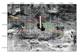
Figure 1: Location of the mud volcanoes (red triangles), mud cones/diapirs (orange triangles) and methane-derived authigenic carbonates MDAC (open red circles) discovered in the Gulf of Cadiz, since 1999 (Gardner, 2000, 2001; Pinheiro et al., 2003; Somoza et al., 2003; Pinheiro et al. (2005); Van Rensbergen et al., 2005a;b; Depreiter et al., 2005). The areas investigated on the scope of teh MVSEIS Project are highlited by circles (orange circles correspond to areas investigated during the last TTR-16 cruise, in July, 2006). |
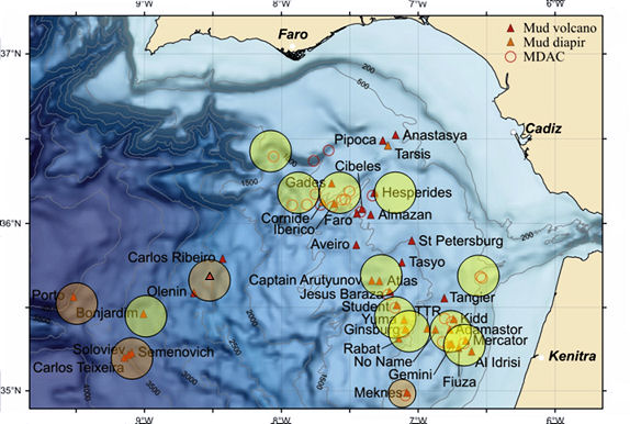
The mud volcanoes are are located at water depths between 200 and 3880 m (top of the mud volcanoes; Fig. 1). Their shape is approximately conical, with a diameter that can reach 5 km and a height that can attain over two hundred meters (Figs. 2-4).
 |
 |
 |
|
|
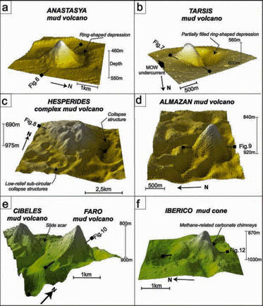
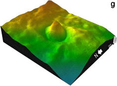
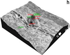
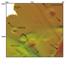
Figure 2: High resolution multibeam bathymetry images of mud volcanoes in the Gulf of Cadiz (Somoza et al., 2003; Pinheiro et al. (2005). (a-f): mud volcanoes and mud cones from the Tasyo field. (g) and (h): Bonjardim mud volcano. (g) mulibeam bathymetry; (h) 12 kHz side-scan sonar image draped over multibeam bathymetry, also showing core locations. |
|
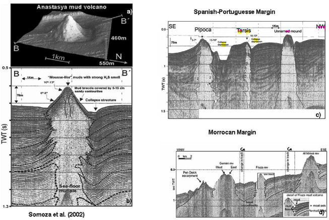 |
|
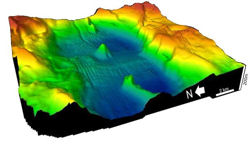
Figure 3: (a) and (b) Anastasya mud volcano. (a) Topography from multibeam bathymetry, showing the surrounding collapse moat around the mud volcano. (b) and (c): High-resolution seismic profiles of several mud volcanoes in the Tasyo field, showing the typical christmas-tree structure, indicative of multiple pulses in the mud volcano activity (Somoza et al., 2003). (d) High-resolution seismic profile in the Morrocan mud volcano field (Van Rensbergen et al., 2005a;b; Depreiter et al., 2005). |
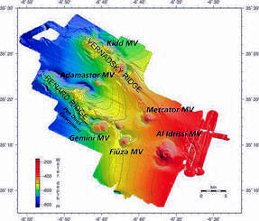
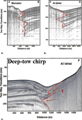
The largest mud volcanoes, e.g. Al Idrissi (Fig. 4,) Yuma, Ginsburg, are located in the Moroccan Sector (Gardner, 2000, 2001; Kenyon et al., 2001; 2002; Pinheiro et al., 2003a,b; Somoza et al., 2001, 2002, 2003; Van Rensbergen et al., 2005a;b; Depreiter et al., 2005; Henriet et al., 2006), whereas the deepest are located in the S. Portuguese margin (Bonjardim, Olenin, Carlos Ribeiro, Porto, Semenovich and Soloviev). The combined interpretation of side-scan sonar mosaics (both 12 and 30 kHz) and seismic profiles (both high resolution, conventional and deep multi-channel) suggest that many of these structures are aligned along major conjugate NE-SW and NW-SE trending faults, or located at fault intersections of these faults or a large WNW-ESE major strike-slip faults and the arcuate thrusts of the Gibraltar Arc system (Pinheiro et al., 2006). Such faults can be imaged in figures 4 and 5.
 |
 |
|
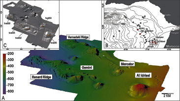
Figure 4: Mud volcanoes from the Al-Arraiche mud volcano field in Gulf of Cadiz. Topography from multibeam bathymetry. (Van Rensbergen et al., 2005a;b) |
|
|
|
|
|
|
|
|
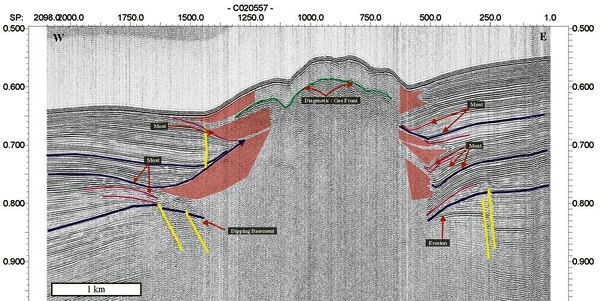
Figure 5: Captain Arutjunov mud volcano. This is one of the most active mud volcanoes, from which gas hydrates have been recovered. This figure shows a high resolution seismic reflection profile across the mud volcano (left) collected in the framework of the MVSEIS project, as well as the corresponding side-scan sonar image (top right) and a detailed bathymetry, showing the structural control of the mud volcano and its association with a mud diapir at depth. |
|
High resolution seismic profiles combined with deep-towed side-scan sonar and high resolution MB bathymetry have been collected in the framework of the MVSEIS project to reveal the detailed internal and external structure of the MVs and to try to image the major fluid conduits (Figs 6 and 7). In particular, a very detailed study of the El Arraiche Mud Volcano Field was carried out by WP-4 (Figs 6, 7 and 8), combining high resolution sea floor and subsurface mapping. This has allowed a detailed description of the mud volcano activity in relation to the structural setting, a description of the morphology of the sediment extrusion and intrusion, the characterization of the faunal distribution at shallow to deep water mud volcanoes in the Gulf of Cadiz, the temporal and spatial variations of mud volcanic eruptions in relation to recent structural evolution of the study area (with details of the history of activity of the MVs), and the correlation of the eruption activity between mud volcanoes in a seismic stratigraphic framework. A morphological comparison with onshore mud volcanoes and magma volcanoes confirmed the occurrence of different morphological end-members in relation to the type of extrusion (Tytgat, Lic. thesis 2005).
|
|
|
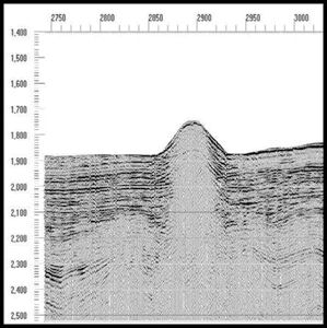
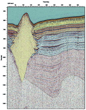
Figure 6: High-resolution seismic section across Mercator mud volcano shows stacked mud flow deposits (in red) around the mud volcano cone. A bottom simulating reflection at the top of the mud volcano (in green) indicates the base of the gas hydrate layer. (from Depreiter et al. 2005) |
|
|
|
|
Figure 7: Very high resolution seismic profiles across several mud volcanoes in the Gulf of Cadiz. Mud volcanoes from the Al-Arraich mud volcano field in Gulf of Cadiz. Topography from multibeam bathymetry. (Van Rensbergen et al., 2005a;b) |
|
|
|
|
|
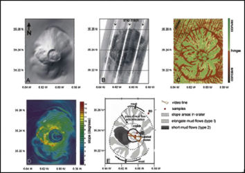
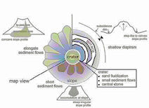
Figure 8: Left: Morphology oft he Al Idrissi mud volcano. (a)Shaded relief map.(b) Side-scan sonar mosaic with bathymetry contours.(c) Curvature of mud volcano isobaths. (d) Slope map with bathymetry contours. (e) Interpretation map. Numerous sediment flow deposits, characterized by high backscatter and convex morphologies, are distinguished on the slopes. They occur in a radial pattern away from the crater and accumulate at the base of the volcanic cone( type I sediment flows) ,which results in a steepening, concave slope profile. On the western slope, sediment flow deposits accummulated at the slope( type II sediment flows) and created a steeper irregular slope profile. Interpretation drawing indicating the main sediment extrusion and intrusion processes and their resulting morphology. The slope morphology is shaped by different types of sediment flows and by uplift caused by sediment intrusion and diapirism. Within the crater the central dome is attributed to diapirism of low-density mud within the volcanic cone, whereas recent sediment extrusion created small debris flows, and fluidized sand flows were issued from secondary vents. |
|
NE-SW trending diapiric ridges with associated carbonate chimneys accurrence are found in the NE sector of the study area (Fig. 9). Several collapse structures surrounding mud volcanoes and large depressions associated with gas escape (pockmarks) are also found in this area (Fig. 9).
|
|
 |
|
Figure 9: Multibeam bathymetry image of the NE sector of the Gulf of Cadiz, showing NE-SE trending diapiric ridges, mud volcanoes surrounded by collapse moats and large depressions at the seafloor associated with gas escape (pockmarks). (from Somoza et al., 2003). |
|

Many of the mud volcanoes appear to have been recently active, given the fact that near-surface gas hydrate can be found, together with a high saturation in H2S and hydrocarbon gases (mainly methane) in the mud breccia and overlying pelagic sediments. Also, chemosynthetic fauna (including Pogonophoran worms) has been observed in many of the cores, grabs and video profiles (Pinheiro et al., 2003).
|
|
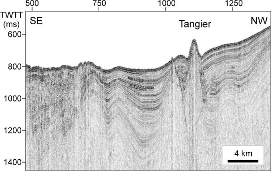
| Figure 10: MVSEIS seismic line acquired during the TTR-12 cruise showing the compressive/transpressive deformation and the structural control on mud volcanism and dispirism in the Gulf of Cadiz. |
Most of the cores retrieved from the mud volcanoes consist of a highly gas-rich mud breccia, with clasts of various lithologies and a strong H2S smell. In the structures that have not been active recently, the mud breccia is sometimes covered by a thin layer of hemipelagic sediment. The study of the mud breccia clasts is very important because they can reveal the age and lithology of the underlying formations, which have been crossed by the rising gas-charged mud at a high pressure, probably along faults. Micropaleontological studies revealed that the older clasts are from the Upper Cretaceous, although the majority of the clasts are of Eocene and Miocene-Pliocene age (Sadekov & Ovsyannikov, 2000).
Last Update 13-02-2008 Webmaster